
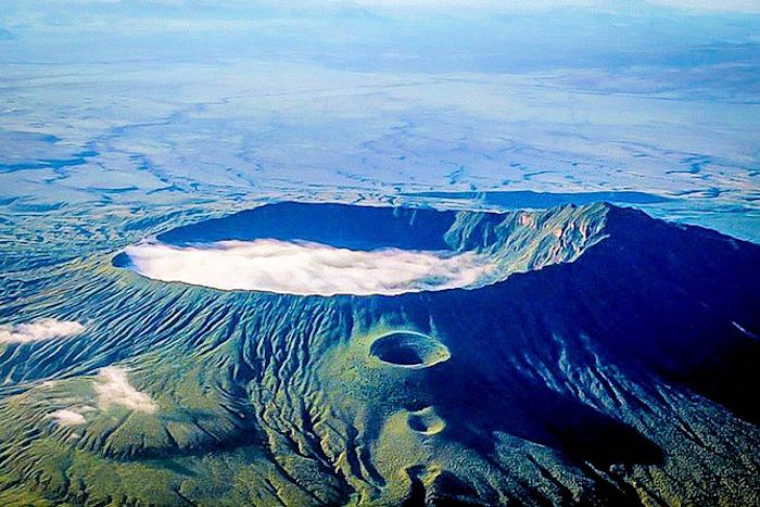
Mount Longonot most recent caldera (pit crater) with line of pyroclastic craters down flank fissure on the north. Massive lava flow on the flank visible on the lower left of the photo. Image courtesy Lonely Planet
Mount Longonot is the neighboring volcano to the north of Mount Suswa we discussed some months ago. Like Suswa, it is a massive stratovolcano with at least two calderas. The ancestral volcano went caldera via an explosive series of eruptions, creating a 8 x 12 km caldera. More recent volcanic activity built a stratovolcano in the caldera which is topped with a 1.8 km crater (caldera).
The volcano is surrounded by the 52 km2 Mount Longonot National Park. It is heavily forested and has the standard compliment of Great Rift Valley wildlife, buffalo, eland, lion, leopard, bushbuck, zebra, giraffe and gazelles. Recreation in the park includes biking, hiking, rock climbing, walking, game viewing, camping, and a large number of birds of prey.

Road from Nairobi to Longonot. National park is depicted as is Lake Naviasha. Suswa and surrounding National Park is to the left. North is up on this map. Image courtesy Amani Gardens Inn, Apr 2016
It is located 90 km NW of Nairobi. Access is available by road.
One of the unique things about this volcano is the heavily vegetated crater floor. This both makes hiking difficult and increases the excitement of potential encounters with lions. This completely different from the thin vegetation on its flanks, likely due to the presence of water and streams from the crater rim.
The northern crater rim tops out at 2,617 m, 750 m above the floor of the Great Rift Valley.

Beginning hike up Mount Longonot. Image courtesy of Opportunity Knocks blog, July 2013
There is a thriving day hike business around and up Mount Longonot. Day hikes up to and around the crater rim are described as strenuous, moderate difficulty, though they are well advertised. The hike is 8 – 9 km long, dusty and steep in places. It takes about an hour from the starting point to get to the crater rim, another 2 – 3 hours around the rim, and an hour or so back to the Park Gate. Hikers should bring drinking water. Most of the reviews from various hiking tour web sites are positive, though there are complaints about filthy trails after trash bins were removed.
There are scenic boat tours on neighboring Lake Naivasha to the north for bird and hippo viewing.
There are multiple webcams for Mount Longonot and neighboring Lake Naivasha. The best one can be found at Ngong Hills.

Geothermal prospects along the East African Rift, Kenya Rift portion. Image courtesy Alexander and Ussher, 2011
Geothermal
Like most volcanoes along the East African Rift, Longonot has been surveyed for geothermal energy potential. July 2009 the Kenya Minisrtry of Energy awarded a commercial resource license for the 132 km2 Longonot geothermal concession. The license allows exploration and construction of a geothermal plant capable of up to 140 MWe, the maximum generation thought to be possible from the field.
The concession is in Kenya Rift Valley, 60 km N of Nairobi and 10 km E of Olkaria Domes geothermal field. This portion of the rift has four recent volcanic systems – Eburru, Olkaria, Longonot and Suswa. They are within 50 km of one another. There are active geothermal systems associated with all four of these volcanoes. Only one of them, Olkaria has been developed, currently generating 200 MW and capable of expansion to 270 Mw.
Longonot was first studied in detail in 1980. Geothermal reconnaissance was done 1985 – 1987. A detailed geothermal study was done in 1998 and again in 2010.

Thermal features verified by 2010 geothermal fieldwork. Concession margin is in yellow. Uncertain older caldera boundary is in blue. Image courtesy Alexander and Ussher, 2011
There are very few thermal features at Longonot, likely due to the arid region. Active fumaroles emit weak steam flows. They are located either in the summit crater or on the main alignment of flank eruptive centers where the pyroclastic are somewhat thinner. Lack of fumaroles elsewhere are thought to be mostly due to thicker pyroclastics.
The most recent geothermal survey has identified a target zone of 43 km2, mostly underlying the caldera and stretching out on the southern slope. Terrain in the northern part of the resource, mostly on the southern flank is steep and difficult to exploit. The survey identified an 8 km2 primary target zone as the most accessible location for drilling. There are multiple cooling intrusives that should be able to drive a high temperature convecting hydrothermal system. No deep drilling has been done on Longonot yet.

Target zone for Longonot geothermal resource. This zone is the most prospective resource to target for geothermal exploration. Image courtesy Alexander and Ussher, 2011
Volcano
Longonot is located 20 SE of the rhyolite dome field of Olkaria and 30 km north of Suswa. Eruptive products in the region vary a bit, with the Olkaria domes being rhyolite, Longonot being primarily trachytes, and Suswa being phonolites. The volcano itself has several parasitic cones.
Volcanic activity for Lonogonot varies between effusive and explosive activity, with effusive mountain-building is followed by explosive caldera formation with extensive pyroclastics. There is usually a smaller cycle of effusive activity following the caldera-forming eruptions, after which the cycle repeats itself.
Analysis of erupted materials concludes that the Longonot magma system over the last 15,000 years evolved similarly to other trachyte centers (Laacher See and the Azores). The magmas originated as basalts and evolved into hawaiites and into trachytes via rapid fractional crystallization with storage times being relatively short at a few thousands of years. This may also indicate a multi-tiered magma chamber.

Conceptual cross section of Longonot hydrothermal system. Pit crater (most recent caldera) is at the top of the image. Image courtesy Alexander and Ussher, 2011
There are seven episodes of activity known from Longonot.
These started with the growth of a voluminous primitive trachyte composite cone, 280 km3. Pyroclastics mantle most of the original lava pile and newly formed caldera. The age of the original edifice is not well known, though it is thought to be active at the same time as neighboring Suswa. Major faulting of the rift floor was also underway, releasing significant flood lavas. Activity at both Suswa and Longonot is thought to start around 400,000 years ago.
Major pyroclastic eruptions took place 21,000 – 6,000 years ago. The caldera-forming eruption took place some 11,000 years ago, bracketed by the pyroclastic activity. Some papers list the original caldera event as 21,000 years ago. Total eruptive output from these eruptions is at least 50 km3. VOGRIPA lists this eruption as a VEI 6.7 taking place some 11,000 years ago. Estimated volume of the newly formed caldera is nearly 27 km3.

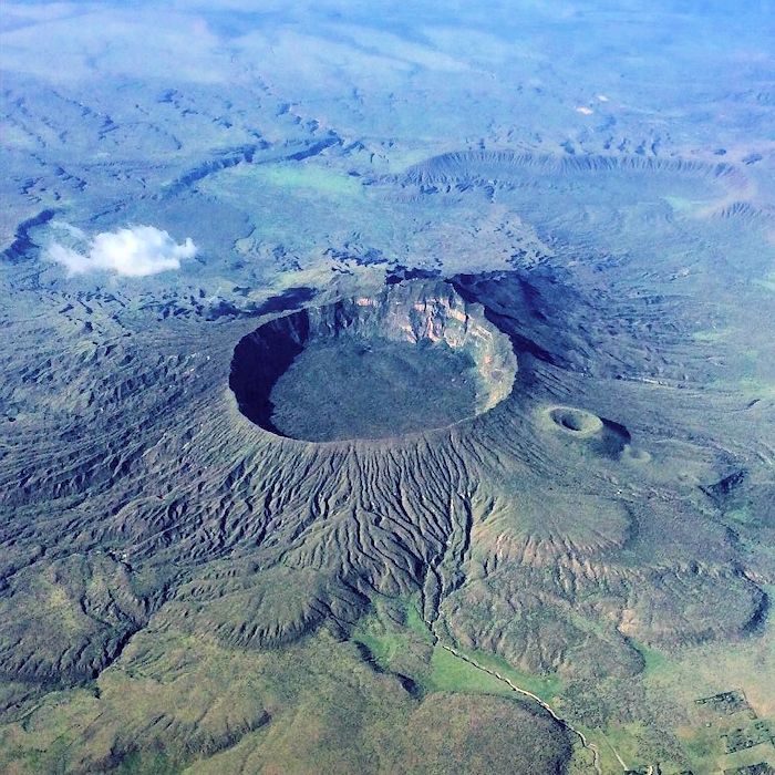
Pit crater of Longonot looking to the east. Image courtesy Kenya Tour Budget Safari
Eruptions following the caldera collapse produced pyroclastic flows, base surges, and airfall deposits. These partly fill the caldera and mantle the caldera walls and volcano slopes. There are multiple base surge deposits and breccias thought to be from the interaction of magma with groundwater following the caldera collapse.
The post-caldera activity is divided into three parts: An early group of mixed hawaiite – trachyte lavas (0.5 km3) on the northern Longonot plains followed the caldera collapse; later trachyte lavas on the main lava pile; finally, a series of ashy eruptions preceding the second caldera collapse.
The trachyte lavas on the main pile partly filled the eastern caldera floor. They were also erupted from flank vents, not unlike what we see with the most recent activity. Total volume of these lavas is at least 16 km3 These lavas have been completely buried in places by subsequent pyroclastics and airfall.

Mount Longonot looking to the south. Image courtesy Geocaching.com, Feb 2013
Explosive activity resumed once again before the second caldera collapse some 3,500 years ago, covering the pile with thick ash layers on the summit of the pile. These eruptions deposited more than 2 km3. The second crater / caldera was formed by asymmetric collapse of the lava pile and ash-covered summit.
Once again, the crater / caldera collapse was followed by effusive eruptions of more than 0.34 km3 of trachytes onto the crater / caldera floor. The most recent activity has been effusive flank eruptions of small trachyte lava flows. The first of these erupted at least four flow units from what appears to be a radial fissure centered on the pit crater collapse. The northern slopes of the main pile have another lava flow with multiple units centered once again on a radial fissure. Both of these flows change from pahoehoe to ‘aa’ lavas with successive flow units. Total lavas are on the order of 0.05 km3.
Current activity is hydrothermal, fumaroles around the base of the pit crater wall.

Lava flows, fumaroles in Longonot. Image courtesy Robertson, et al, 2016
Activity has migrated eastward over the history of this volcano. This migration may be related to cross-faulting on the rift floor beneath the edifice.
Longonot has been a productive volcano, erupting over 156 km3 of trachytes, less than 1 km3 of mixed lavas, and over 192 km3 of pyroclastics. The history and nature of volcanic activity from Longonot suggest the continued presence of a large, shallow magma chamber. It is still believed to be molten based on recent Longonot effusive activity and is the heat source for geothermal activity.
The NNW – SSE alignment of flank eruption centers and fissures are thought to be the surface expression of ongoing regional extensional tectonics. These faults are not visible at the surface due to a thick covering of pyroclastics and lavas.

Neighboring volcanoes to Longonot. Location in the Kenya Rift. (C) is a schematic stratigraphic column for Longonot sequence. Image courtesy Rogers, et al, 2004
A comparison of the three neighboring volcanoes, Menegai 80 km north, Suswa, 15 km to the south suggest that the three systems were active during the same time and had similar eruptive styles. The first caldera collapse events created elliptical calderas along an ENE axis. Explosive activity took place at all three volcanoes during caldera collapse. Pyroclastics at all three volcanoes suggest that the caldera forming eruptions may have taken place around the same time, a possible regional episode of caldera formation. Recent lava flows 100 – 300 years old were erupted from all three centers.
There are differences between the three volcanoes. Longonot is the only one to show a pre-caldera succession of pyroclastics and lavas. Menengai does have trachytic ignimbrites on top of pre-caldera lavas. At Longonot and Suswa, post-caldera activity built secondary lava volcanoes on the original caldera floor. In both, the summits of the secondary lava volcanoes collapsed to form pit craters. Suswa has a third major collapse feature, forming the annular ring graben. Longonot is the only volcano with mixed basic-felsic lavas. These are the first products erupted after each major collapse event. Successive major centers of activity at Longonot and Suswa have migrated east with time. Longonot and Suswa are more similar to one another.

Satellite view of Longonot. Two most recent lava flows are clearly visible extending north and SSW from the flanks of the newly built cone. Pit crater is clearly visible to the right of the orange marker. Part of the caldera rim from the original caldera is visible to the left of the new cone. Screen capture via Google Maps
Eruptions
The most recent eruption was in 1863. Masai tradition describes recent eruptions from the north flank during the 19th Century, likely the 1863 eruption. Similar young flows are on the SW flank. The date of the southern flow is unknown. The northern flow came from a single pyroclastic cone. The southern one came from a fissure with six small craters. Both lavas are trachytes with an ‘aa’ surface.
There are over 50 fumaroles within the crater. Three of these are on the southern wall. There are inactive / fossil fumaroles on the rims of pyroclastic cones on the northern flank. Subsequent geothermal resource assessments located 11 active fumaroles in the summit crater, crater wall and flank eruption centers.
InSAR observed a 9 cm surface uplift Jun 2004 – Mar 2006. No ground deformation was observed prior to 2004. After 2006, there was a small subsidence rate observed until 2010. Radar coverage was not available after 2010. Modeling of the shallow activity suggests that the hydrothermal system was perturbed by a deep magmatic injection 2004 – 2006, heating the overlying boiling aquifer.

InSAR uplift of Longonot observed 2004 – 2006. Image courtesy RN Scoon, 2018
The presence of the rift volcanoes in Kenya, along with calderas, pyroclastics, and signs of unrest suggest the Kenya Rift is still capable of producing large volcanic eruptions. There are few historic records of minor volcanic activity. There is little ground-based monitoring, and no understanding of frequency and magnitude of past eruptions. Baseline records of diffuse degassing do not exist. Compared to other volcanic regions, the assessment of hazard and risk is unquantified, entirely due to records of recent activity. Given that over 410,000 live within 30 km of Longonot and 8.7 million within 100 km, the volcanic hazard and risk of the region must be assumed to be high.
There was a brief scare in 2012 as what was described as “huge gullies” opened following heavy rains, flooding and the draining of those floods. Along with these gullies, was the emergence of a major fault line. This is a 5 km fault from Longonot that continues to spread. There was media fanned concern that the volcano was once again waking up. As I understand the geography, this is taking place to the north of the volcano, between it and Lake Naivasha. Given the ongoing rifting, active faulting, and widespread coverage of the flanks and surrounding region with ash and pyroclastics, water washing away soft material covering active faulting is not unexpected.

Schematic of Kenya Rift portion of East Africa Rift. Also depicted is the Tanzania Craton, Kenya Dome and location of the superplume underneath Ethiopia. Triple junction in the Afar is off the map to the NE. Image courtesy EGU Blogs, Jun 2018
Tectonics
Longonot is located in the Kenya Rift Valley, part of the East African Rift. It is at the southern end of the Naivasha trough. The Mau escarpment to the west is faulted. The rift valley lies along the N-S axis of the Kenya Dome, a regional rise in the crust some 500 km in diameter centered 80 km north of Longonot. The central volcanic province of Kenya from north to south includes Nenengai, Eburru, Longonot and Suswa.
The major tectonic activity in this region is the rifting of the African continent. The East African Rift is connected to the Afar Triangle, the Gulf of Aden and Red Sea Rifts, with the triple junction underlying the Afar. The rift then continues south and branches on either side of Lake Victoria around the Tanzanian Craton / Kenya Rise. The eastern branch of this is the East African Rift. The portion of this that goes through Kenya is called the Kenyan Rift. It is an extensional region.

Rifting due to underlying fault perhaps 10 km to the ESE of Longonot. Rifting took place in 2018 near Mai Mahui. Image courtesy Prothom Alo, Apr 2018 (publication date of Apr 1 worries me a bit)
Our Nyiragongo post in 2018 covered the tectonics of the East African Rift extensively.
The East African Rift includes 106 volcanoes, 18 of them active, 38 restless, and 50 dormant. Most of these are located in the northern portion of the rift (Ethiopia and Eritrea).
Satellite radar (InSAR) surveys of the rift system have detected at least 22 deforming volcanoes. This may indicate the presence of active magmatic systems or changing hydrothermal systems. Some of these erupt. Some of these show pulses of uplift and subsidence. Longonot is one of these. Others like Menengai and Suswa show singular subsidence events, which is both unusual and does not fit the traditional volcano model. Causes of this are currently unknown.
Volcanic and magmatic activity in the rift are ultimately due to processes in the underlying mantle. These are in turn driven by the African Superplume.
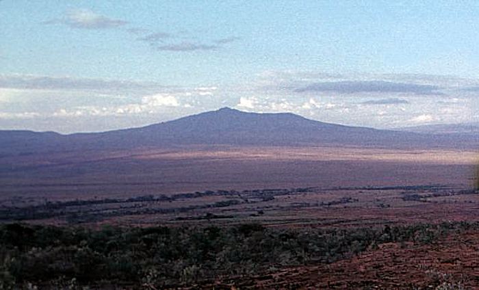
View of Longonot looking to the north. Image courtesy Tom Jorstad, 1990 via Smithsonian GVP
Conclusions
While Mount Longonot is not recently active, it was built in the middle of an active continental rift. This rift opened enough to allow sufficient magma to reach the surface to build multiple recently active volcanoes along its axis. All volcanoes are associated with active geothermal fields which are being surveyed and exploited for electrical generation. Longonot appears to currently be in an effusive portion of its activity cycle. Still, it has formed at least two calderas over the last 21,000 years. And an active volcano within 30 km of 410,000 and 100 km of 8.3 million (mostly in Nairobi) is one that should be treated with a great deal of respect.
Airborne image of Longonot. North flank pyroclastic craters visible. Multiple lava flows visible. Western caldera rim segment also visible. Image courtesy Pintrest.com
Additional information
https://volcano.si.edu/volcano.cfm?vn=222100
https://www.volcanodiscovery.com/longonot.html
http://volcanolive.com/longonot.html
https://africansermonsafaris.com/mount-longonot-day-trip-hiking/
https://royalsocietypublishing.org/doi/10.1098/rsta.1980.0188
https://www.geothermal-energy.org/pdf/IGAstandard/NZGW/2007/035_Onacha.pdf
https://www.frontiersin.org/articles/10.3389/feart.2016.00086/full
http://citeseerx.ist.psu.edu/viewdoc/download?doi=10.1.1.555.9326&rep=rep1&type=pdf
https://academic.oup.com/petrology/article/45/9/1747/1503453


M5.3 quake this morning just before 1000L (about 0+45 ago). Sharply felt. I was on the road and didn’t notice it. 13 km N of Anchorage. Depth of 42 km. Classified as an aftershock of the Nov 30, 2018 M7.1. UAF Seismology Lab event page at the link below.
It takes at least a M5.3 to start knocking stuff over on shelves in our home. Cheers –
https://earthquake.alaska.edu/event/0212o88mof
LikeLike
Earthquake swarm at Mount Hood earlier this week. 5 km deep. Blamed on hydrothermal system of the volcano. Link to local story follows. Cheers –
https://www.sacbee.com/news/nation-world/national/article249656663.html
LikeLike
Pingback: Revisiting Menengai Crater, Kenya |