File:Great Rift Valley map-fr.svg
Jump to navigation
Jump to search

Size of this PNG preview of this SVG file: 465 × 599 pixels. Other resolutions: 186 × 240 pixels | 372 × 480 pixels | 596 × 768 pixels | 795 × 1,024 pixels | 1,589 × 2,048 pixels | 1,403 × 1,808 pixels.
Original file (SVG file, nominally 1,403 × 1,808 pixels, file size: 1.05 MB)
Captions
Captions
Add a one-line explanation of what this file represents
Summary[edit]
| Description |
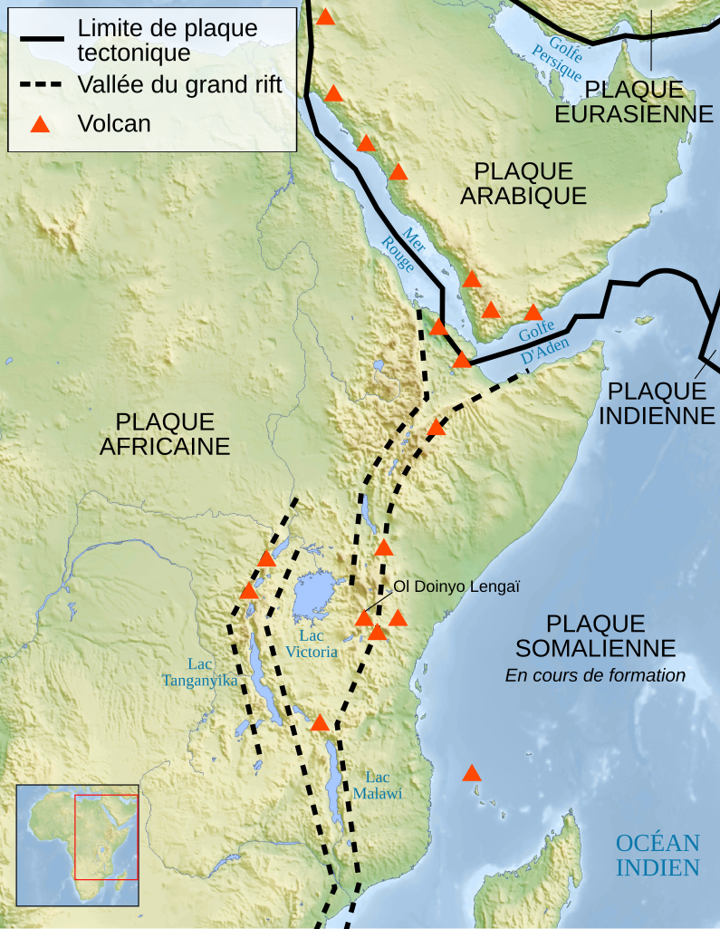
English: Map of the Great Rift Valley. French version. The background map and the locator map are raster images embeded into the SVG file.
Français : Carte de la Vallée du grand rift. Le fond de carte et la carte de localisation sont des images matricielles embarquées dans le fichier SVG.
Español: Mapa del Gran Valle del Rift, en francés. |
||
| Date | |||
| Source |
travail personnel (own work). Sources :
|
||
| Author | Sémhur | ||
| Other versions |
Derivative works of this file: | ||
| Attribution (required by the license) | © Sémhur / Wikimedia Commons / | ||
| SVG | W3C-validity not checked.
|
||
| Graphic Lab |

| Camera location | | View this and other nearby images on: OpenStreetMap |
|---|
Licensing[edit]
I, the copyright holder of this work, hereby publish it under the following licenses:
| Copyleft: This work of art is free; you can redistribute it and/or modify it according to terms of the Free Art License. You will find a specimen of this license on the Copyleft Attitude site as well as on other sites. |
This file is licensed under the Creative Commons Attribution-Share Alike 4.0 International, 3.0 Unported, 2.5 Generic, 2.0 Generic and 1.0 Generic license.
- You are free:
- to share – to copy, distribute and transmit the work
- to remix – to adapt the work
- Under the following conditions:
- attribution – You must give appropriate credit, provide a link to the license, and indicate if changes were made. You may do so in any reasonable manner, but not in any way that suggests the licensor endorses you or your use.
- share alike – If you remix, transform, or build upon the material, you must distribute your contributions under the same or compatible license as the original.
You may select the license of your choice.
File history
Click on a date/time to view the file as it appeared at that time.
| Date/Time | Thumbnail | Dimensions | User | Comment | |
|---|---|---|---|---|---|
| current | 19:27, 10 June 2008 | | 1,403 × 1,808 (1.05 MB) | Sémhur (talk | contribs) | Move "Plaque Somalienne" label and add a precision |
| 09:21, 10 June 2008 |  | 1,403 × 1,808 (1.05 MB) | Sémhur (talk | contribs) | + volcanoes and some place names. | |
| 11:43, 9 June 2008 |  | 1,403 × 1,808 (1.04 MB) | Sémhur (talk | contribs) | Without the bitmap... | |
| 11:38, 9 June 2008 |  | 1,403 × 1,808 (1.12 MB) | Sémhur (talk | contribs) | {{Information |Description={{en|1=Map of the Great Rift Valley. French version. The background map and the locator map are raster images embeded into the SVG file.}} {{fr|1=Carte de la [[:fr:Vallée du grand rift|Vallée du grand |
You cannot overwrite this file.
File usage on Commons
The following 4 pages use this file:
File usage on other wikis
The following other wikis use this file:
- Usage on bg.wikipedia.org
- Usage on fr.wikipedia.org
- Usage on hi.wikipedia.org
- Usage on it.wikipedia.org
- Usage on la.wikipedia.org
- Usage on mg.wikipedia.org
- Usage on mk.wikipedia.org
- Usage on oc.wikipedia.org
- Usage on rw.wikipedia.org
- Usage on uk.wikipedia.org